|
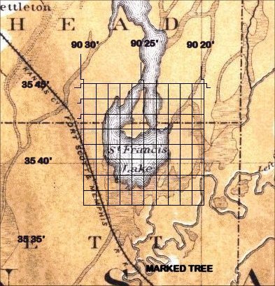
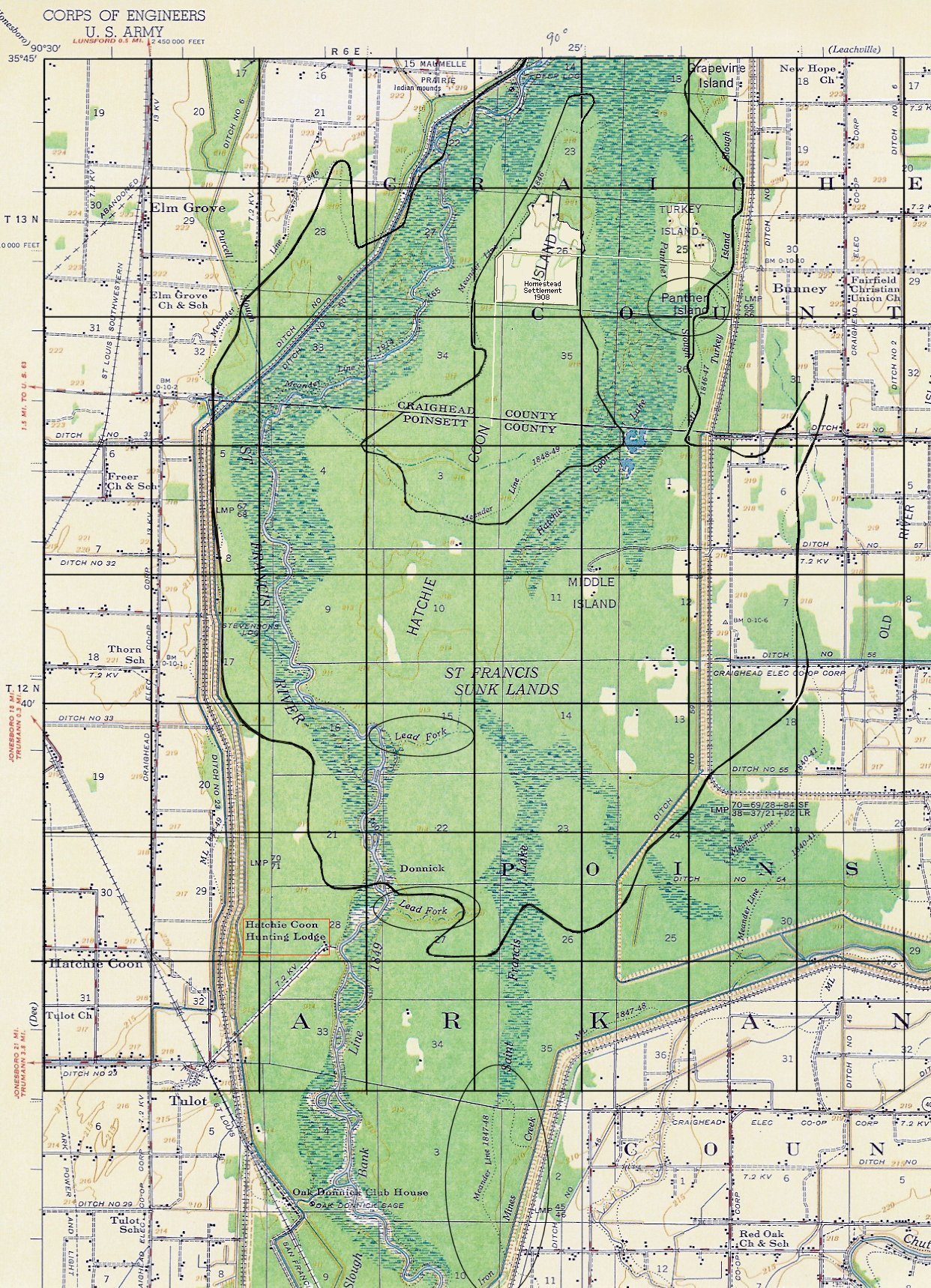
The 1889 edges of St. Francis Lake fairly well correspond to the
meander lines of 1845-1849 which are shown on the 1956 topo map.
The clear cut area near the north end of Hatchie Coon Island was apparently
a Homestead Settlement back in 1908. It is accessible from the east
via Craighead County Road 82, which is also known as Hatchie Coon Road.
[Added 06 Jan 2006.]
About a mile east of the homestead settlement just mentioned, is an
area known as Panther Island. This area is enclosed inside an oval
on the topo map. Shawnee Chief Tecumseh
is credited with prophesying that a continent shaking catastrophe would
occur on December 16th 1811. The name Tecumseh means Panther in the
sky. Anybody having knowledge of how Panther Island came to have that
name please contact the author. (Does Indian history in any way connect
Chief Tecumseh with Lake St. Francis?) [Added 28 Feb 2006.]
Click here to see a blink comparator of a
satellite photograph of the area and an elevation contour
map. Note the high ground located in the upper right hand part
of the contour map. [Added 18 Nov 2006.]
At the bottom of the section of the USGS topo map, shown just above,
there is a ditch located along the inside edge of the eastern levee
which borders the St. Francis sunk lands. The ditch is labled "Iron
Mines Creek." (This name is enclosed in a elongated vertical ellipse.)
Anybody having knowledge as to whether there ever were iron
mines in the St. Francis Lake area, and if so, where they were, please
contact the page author. Also, on the St. Francis river, itself, near the
former southern boundary of St. Francis Lake, are two annotations,
"Lead Fork." (These are enclosed in the shorter horizonatal ellipses.)
If anybody knows what the meaning of these notations are,
especially if the words "Lead" pertain to the metallic element bearing the
same name, please contact page author. [See correspondent's comments
below.] [Added 26 Feb 2006.]
If you visit the Arkansas
Mineral Commodity
Search Map and select the commodity iron ore you will find that
no iron ore sources, present or abandoned, are displayed in the region
between Jonesboro, AR and Memphis,TN. [Added 22 Apr 2017.]
According to Scott May, a member of the
Hatchie Coon Hunting and Fishing Club,
Inc., the 1849 meander line (shown on the 1956 topo map
above) is a misnomer, because when the surveyors came in the winter of 1849,
the water was too deep in the area near Hatchie Coon. This fact is reflected
on the surveyor's notes available in the State Land Office in Little Rock,
AR. [Added 08 Aug 2006.]
According to May, the southern "lead fork" is locally known as "Stud Horse
Run," and the fact that the same name appears in two different locations
may be a mapping error. He says (with respect to the word lead,
as in lead forks) "It is definitely lead as in the metal.
I have never heard it pronounced as in to "lead" the horse to water."
[Added 08 Aug 2006.]
The hunting and fishing club, mentioned above, is located on the west side
of the St. Francis river, southwest of the lower "lead fork." On the
1956 topo map, it is located inside the red rectangle. [Added 09 Aug 2006.]
If there were any lead or iron mines, however temporary, in the Hatchie
Coon/Saint Francis Lake area, then there may be old photographs, news
clippings, or other narrative materials relating to them. These could be
tucked away in albums or stored in other keepsake stashes. Any
readers who can find any materials of this nature, which provide dates,
names, locations, etc., of the mines, is heartily encouraged to contact
the author. They can be incorporated on this webpage. [Added 08 Aug 2006.]
In this light, the author was told by a CPA in Marked Tree, AR that Chief
Tecumseh had a son (or nephew) who lived in the northeast Arkansas area,
who had written a book (or pamphlet?) about matters related to the 1811-1812
earthquakes. A copy of that document would be very helpful.
[Added 08 Aug 2006.]
|