Prev | 1 | 2 | 3 | 4 | 5 | Next
27 February 2004
A researcher of volcanic activity at Stromboli says he doesn't think
Stromboli can be a source of sufficient ash for [the] Canneto [problems].
He also says that Mt. Etna has not been very active lately. He asks,
"Why would it [the accumulation of ash/or the fires] happen only at Canneto?"
It may well turn out that volcanic ash is not involved in the Canneto fires. On the other hand, if it is a factor, and Mt. Etna and Stromboli become ruled out as the source, then we are free to ask whether there is any other volcanic source (possibly new) which is near to Canneto. (This is, of course "volcano bashing.") Seismic records and infra-red/or SeaWifs satellite imagery might provide clues. [See the 5 March entry, below, for an additional spaceborne sensor that might be called into play.] Other hitherto ignored (or misinterpreted) visual observations might be re-evaluated. The author came across one instance where a new undersea volcano southwest or west of Sicily, back in the 1800s, was, for a while, thought to be a steamship "stuck" in one place just over the horizon. Also, passing seafarers didn't connect the multitudes of dead fish in the area, or the bubbles in the water, with a new volcano until lava and fire broke the surface. [Looking for reference.]
According to Thomas Gold(1) gases that stream up out of rocks during or prior to earthquakes are frequently flammable. He says [paraphrased] that the mere existence of diamonds at great depths proves that unoxidized carbon exists there, and that the two types of fluids to consider in the diamond concentration process would be carbon dioxide and methane, the latter possibly associated with heavier hydrocarbon molecules. He says that, according to Melton and Giardini (1974), tiny pore spaces in diamonds have been found to contain small amounts of highly compressed gases, among which the carbon-containing ones were both carbon dioxide and methane.
For more on gases associated with, or even causing, earthquakes, see Thomas Gold's "Eye-witness Accounts of Several Major Earthquakes" (2). This document also describes a variety of surface electrical phenomena as precursors and side effects of earthquakes. [Added 18 March 2004.]
If the fires at Canneto turn out to be related to flammable gases seeping up through the ground, then they may be precursors to an upcoming local earthquake. Is there a seismic fault line associated with the cliff south of Canneto? Did residents in the area detect unusual odors/smells back when the fires were occurring?
[Oops! Methane is odorless and is lighter than air. Inside houses and buildings it would tend to collect near ceilings and perhaps inside objects that have restricted exits for vertical airflow. Bed box-springs and leather or vinyl covered sitting furniture come to mind. Have Methane detectors been used in Canneto? Some other flammable gas may be the hypothetical culprit. [Added 18 March 2004. Updated on 14 Feb 2016.]
References are at the end of section 5.
1 March 2004
Recent news reports say that at Canneto some fires have even broken out in
(or associated with) water pipes. That makes it sound as though flammable
gases may in fact be seeping to the surface. Earthquake or volcano
precursors seem possible. Some sources reported that special teams have
visited the area armed with seismic activity sensors. With the idea in mind
that volcanic related activity may be at work, the author has begun a
study of recent USGS earthquake information for the Mediterranean area.
(If author's memory serves right, when quake activity drops off in a
normally active quake region, something our of the ordinary may be
in the making.)
Since 15 January the closest that any earthquake was to Canneto was about 186 nautical miles due South in the central Mediterranean (Lat 34.9N Long 14.4E). The location of that earthquake, which occurred on 19 January, is shown as a white dot on the map below.
The author is not familiar with the earthquake history around Sicily but thinks it odd that with all the volcanoes in the area, no quakes with magnitude greater than 1.0, closer than the one just mentioned, have occurred on or close to Sicily since mid January. The total numbers of earthquakes (in 5 degree Latitude by 5 degree Longitude bins) are shown for February 2004. (These totals represent quakes which were less that 1000 nautical miles from Canneto. Quakes in Portugal and in the westernmost part of Spain were not used in the totals.)
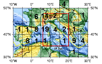
Map of Mediterranean Area Showing Earthquake Activity for February 2004
The red border represents the boundaries of the area covered by the seismic bulletins linked to below.
(Original map is from USGS.)
18 April 2004 - Special (out of sequence) note
No earthquakes for Sicily or the southern part of Italy were reported by USGS for the month of March 2004.
The following three paragraphs and graphics were added 6-8 April 2004.
The map above may make it seem that no earthquakes were occurring in February 2004 in the Sicly area. That is not the case. The USGS earthquake data used above, as mentioned, does not include quakes of magnitude less than 1.0. Italy is generally alive with lower magnitude quakes. Etna area quake activity for the year of 2004 (rather than being skimpy as previously reported) seems to have been fairly typical to date. [Last sentence was replaced on 8 May 2004.]
Viewers with high speed internet access (DSL for instance) are invited to see continuous loop gif animations of earthquake activity in the central Mediterranean region for the years of 2002, 2003 and thru March 15th of 2004. If you try to load the 2.05 Megabyte animation with a 56 Kbps modem, plan on spending about seventeen minutes for a complete load. The smallest file (for 2004) should take about three minutes to load at 56 Kbps. Single frames for selected half-month periods in each year have been added for faster inspection.
The images used in the animations are published on the web as seismic
bulletins by the
Centro Nazionalie Terremoti(*) of Italy's Instituto Nazionale di
Geofisica e Vulcanologia. On each animation the author has inserted a
circle of 32 nautical mile radius, centered on Mt. Etna. The circles
represent the author's "gut feeling" for the horizontal boundary for Etna
related earthquakes. At the bottom of each animation there is a histogram
with a running marker that shows the numbers of earthquakes inside
(or on the edge of) the circle in half month periods.
(*) The URL http://www.ingv.it/~roma/reti/rms/bollettino/boll.htm to
this site needs updating. [22 August 2005]
2002 Movie (2.05 Megabytes) -
Oct 16-31, 2002
2003 Movie (1.86 Megabytes) -
June 1-15, 2003
2004 Movie (0.70 Megabytes) -
Feb 1-15, 2004
5 March 2004
[Extract from a February 6, 2003 Associated Press article titled
Mount Etna Waiting to Erupt by Randolph E. Schmid. Link no longer works 30 Mar 2010.]
"The magma [underneath Mt. Etna] rises in the area of two intersecting faults in the
rock beneath the mountain, triggering earthquakes as the pressure increases. The team [from the National Institute on Geophysics and Volcanology in Catania] found what they believe is a massive body of solid magma intruding from about one mile to about 11 miles deep beneath the mountain, causing a pressurization of the mountain's deep plumbing systems which has fractured the rock. The rising liquid magma is moving through the cracks and fissures and collecting in an area about 1.8 miles below the surface."
Perhaps some of the liquid magma has been forced into branched subterranean pathways and is approaching the surface in the vicinity of Canneto di Caronia. [An estimate of the horizontal dimensions of the mountain's deep plumbing system was not given.]
In addition to the space sensors mentioned in the 27 Feb entry, it may be
that the high spatial resolution joint US/Japan Advanced Spaceborne Thermal
Emission and Reflection Radiometer (Aster) onboard
NASA's Terra spacecraft(*) might be employed to look for gaseous or
aerosol evidence of emerging volcanic activity near Canneto.
(*)The URL http://www.jpl.nasa.gov/releases/2003/14.cfm to this NASA
site needs updating. [22 August 2005]
8 March 2004
The following NASA MODIS image, made on 27 October 2002, shows, in addition to Mt. Etna's volcanic plume, what seems to be a water plume that possibly originates on the western part of Sicily. A group of green vegetative areas may be supplying the moisture in the water plume. (Both plumes appear to be being carried by the prevailing wind in the same general direction.)
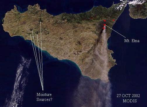
My interpretation of Google Earth imagery for these vegetative areas is that they look like mountain top volcanic features. Carbon dioxide emissions from old (but not dead) vents might enhance greenery. The carbon dioxide, being heavier than air, would tend to flow downhill.
There are good sized lakes (surface areas greater than 0.3 square miles) all
over Sicily but best I can tell none of them that are located away from
these vegetative areas seem to cause water plumes. [Added 11 Sep 2013.]
Here is a Google Earth image of Sicily showing the hypothetical moisture sources
and lakes.
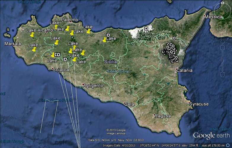
The round markers, near Mt. Etna, correspond to outlying volcanic cinder cones. The square markers correspond to suspected volcanic vents, some of which may still produce gaseous water vapor emissions occasionally. The white lines (all jammed together) are elevation contour lines which can't be resolved at the mapping scale of this image. [Added 11 Sep 2013. Updated 12 Sep 2013.]
Here is a closer-in view of the eastern part of Sicily, where, again, the small circlular markers represent Etna's outlying cinder cones. I have not shown all 300 cones. The larger circular markers, close to the peak of Etna, indicate volcanic calderas. The square marker, near the north central coast, represents the location of a (for sure) surface lava source associated with a formerly active volcanic process. Whether or not it was fed by Etna's plumbing is unknown to me. (There other apparent volcanic vents in that area but I haven't dug into appropriate geological sources yet to validate them. At the scale of this image it can be seen that the elevation contours in the Canneto area (left end of the red line) are busier than those to the East of Caronia. I suspect that there are also some old lava flows in the hills above Canneto.
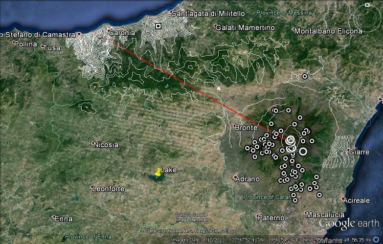
Outlying cinder cones of Mt. Etna
Here is a bird's-eye-view of what I interpret to be a Sicilian lava flow termination, associated with the lava source symbolized in the previous image. The view is looking South from above the coastal town of Acquedolci. The source (square symbol) is 11.3 miles from Canneto.
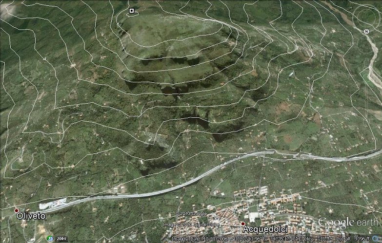
Lava Flow termination? - Elevation contours are spaced 200 feet apart.
The A20 toll road is in the foreground.
Readers who have knowledge of what was really going on with the apparent water plume are invited to send their comments to the page author for inclusion in this study.